-
Taking On Domestic Violence in Post-Conflict Liberia
›Liberia is a case study in post-conflict violence against women, said panelists at the Wilson Center on July 24. “Confined merely to performing household chores and childrearing duties, from early childhood, women and girls have been socialized into subservience and powerlessness and acceptance of domestic abuse as a norm,” Annette Kiawu, deputy minister for research and technical services at the Liberian Ministry of Gender and Development, told the audience. [Video Below]
Kiawu was joined by Pamela Shifman of the Novo Foundation and Esther Karnley and Elisabeth Roesch of the International Rescue Committee (IRC). They discussed the prevalence of domestic violence in Liberia after the 14-year civil war, which ended in 2003.
Violence Stemming from Changing Norms
Kiawu pointed to women’s changing roles in Liberia as a source of household tension. She noted that women are increasingly “demanding a greater role in household decision making,” which some men see as “encroachment on their sphere of influence.”
“According to the LDHS [Liberia Demographic and Health Survey], the persistence of domestic violence is directly linked to the increased status of women on the one hand and men’s [perception] of loss of power and authority on the other,” she said. Some men’s urge to assert dominance is exacerbated by higher levels of alcohol abuse and a tendency towards violence learned during the civil war.
There has been legislation against gender-based violence – including the Rape Amendment Act, also known as the “revised rape law,” the Revised Gender-Based Violence Action Plan, and the African Union Protocol – as well as action plans and community-based groups meant to decrease the rate of domestic violence, like the Gender-Based Violence Network, an initiative designed to increase community ownership of domestic violence issues and improve response at the grassroots level. But despite these advances, Kiawu stressed that there still is a long way to go, saying that increased funding and coordination between domestic and international agencies and the Liberian government is necessary to have a real impact on the lives of the “countless women” whose lives are threatened by domestic violence.
Making Reality Match Rhetoric
Pamela Shifman agreed that domestic violence prevention programs need more funding. “So often in conflict-affected settings we hear that we need to address other issues first…that domestic violence is a back-burner issue,” she said. Domestic violence is often perceived to be “not that serious” when compared to other issues in conflict-prone and post-conflict countries.
But Shifman argued that divorcing domestic violence from other types of violence is problematic. “Violence in the home normalizes violence in the street, normalizes violence in the community, and normalizes violence by the state,” she said.
NoVo is one of the few private organizations which prioritizes domestic violence and gender equity, Shifman said, but she asserted that all humanitarian organizations should devote time and money to these issues, saying that “if we ignore domestic violence, all of the other investments we make to improve the quality of life for communities will suffer.”
Empowering women can have significant results for the whole community. Shifman remarked that “investing in women is smart economics,” citing studies which suggest directing funds towards women “pays off at huge levels” for women’s families and communities. But when women experience violence, “their potential is thwarted,” she said. “They suffer, their families suffer, their community suffers, the entire nation suffers.”
Programs targeting domestic violence need greater awareness, more long-term commitment, and more funding, she said. “We don’t expect that violence is going to end overnight – no deep-seated social problem will be solved that quickly,” she said. “In order to make a dent in improving the lives of girls and women and ending violence against girls and women, we need more direct funding” from private and public sources.
“To put it bluntly, I think the reality needs to match the rhetoric,” Shifman concluded.
Perspectives from the Field: Social Isolation
Esther Karnley described the results of interviews conducted with Liberian women, both survivors of domestic violence and fellow community members. She found that a key reason women stay in abusive relationships is financial dependence. “Most of them said, ‘it’s because we depend on the men for everything… we don’t have any money, we are not empowered financially, we depend on the men for everything. Because of that, we remain in that relationship and we get killed.’”
She added that social isolation means that many women lack the resources to leave a relationship. “We are isolated socially, we don’t have access to services, we are all by ourselves,” they told her. Without support from friends, relatives, or organizations, it can be difficult to find the means to relocate.
Part of the problem in Liberia is the prevalence of informal education, especially Sande bush schools – schools run by a traditional women’s society designed to prepare girls for marriage, teaching them traditional housekeeping methods and culminating in female circumcision. Girls leave home to attend these traditional schools for several months, which severely curtails their access to formal education. Kiawu reported that “over 60 percent of girls attending Sande school drop out of regular school.” This means that “successive generations of young children, especially young girls, are expected to forgo formal education in favor of attending the Sande school.”
In addition to formal education, Karnley said financial empowerment and legislation holding perpetrators of domestic violence accountable for their actions would enable more women to leave abusive relationships.
Reaching Both Women and Men
Each of the panelists recognized that working against domestic violence requires comprehensive societal reforms. Karnley stressed that the impetus to begin working with men came from Liberian women. “Initially when we started working on GBV issues, we talked to women, and then the women came and said, ‘OK, you talk to us every day, and when we go home, we go and meet fire. Can you also talk to our men?’” In response, the IRC developed a 16-week program designed to change men’s behavior and views about violence and relationships. Karnley also mentioned a desire to reach out to the religious community to change the constant focus on the man as the head of a relationship to one based on love.
The Liberian government is also working with churches and mosques to change norms that encourage the subjugation of women, including work with a network of religious leaders known as Christian/Muslim United against SGBV (sexual and gender based violence). Kiawu said this organization emphasizes partnership within a marriage and teaching equality to children in the home. The panelists also mentioned additional efforts to increase the responsiveness and sensitivity of the police and judicial system to domestic violence issues, as well as the need for resources like safe houses to provide relief to survivors.
“The family, far from being off limits, has to be a priority for us in the humanitarian community as we help to rebuild nations where peace not only exists between nations, and among nations, and among communities, but among families,” Shifman contended. Kiawu agreed, adding that without interventions, violence and isolation prevent women “from taking advantage of opportunities that peace presents.”
Event Resources: Photo Credit: A woman prays during a Sunday morning service in Monrovia, courtesy of Bruce Strong/Newhouse School. -
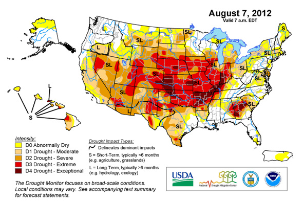
U.S. Drought, Climate Change Could Lead to Global Food Riots, Political Instability
›August 15, 2012 // By Graham Norwood
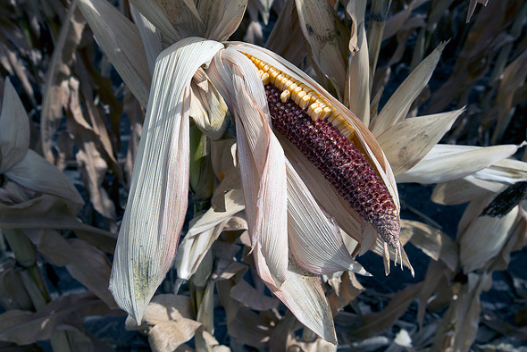
It’s been a difficult year for U.S. agriculture. Record high temperatures and the country’s worst drought since 1956 have combined to decimate crops across the nation, and some forecasters are predicting more heat and dryness in the months ahead. Things have been so bad that many experts fear a recurrence of the food riots and instability that shook the world in 2007-8, and again in 2010-11. Others point to this year’s unusual weather in the United States and elsewhere as a harbinger of how climate change might impact humanity in the 21st century.
Things started out well enough earlier this year, as America’s farmers took advantage of the warmest March weather on record by planting the largest corn crop in 75 years. As late as May 10, the USDA was projecting that previous corn production and yield records would be shattered. “We’re looking at the potential for just a true bin-buster of a crop [this year],” grain expert and Iowa State University economics professor Chad Hart told The Huffington Post at the time. “There’s going to be a lot of corn flying around here.”
But those predictions came before a historic drought descended upon the country’s heartland, accompanied by soaring summer temperatures. In July, the USDA slashed its estimate for corn production by 12 percent, the largest such adjustment in a quarter century. The organization released an even bleaker update last Friday. Meanwhile, many commodity traders, believing the worst may still be yet to come, have reduced their own projections even further. Soybeans, which are frequently intercropped with corn, have also struggled with this summer’s conditions.
As optimism for the corn and soybean harvests has faded, commodity prices have surged. Corn futures have reached record highs, and soybeans have also seen dramatic price increases. Both commodities have now surpassed their peaks from the 2007-8 crisis that led to riots in more than two dozen countries across the world.
Even wheat, which is primarily a winter crop, has experienced a price increase of about 50 percent over the past two months. “If the price of corn rises high enough, it also pulls up the price of wheat,” Robert Thompson, a food security expert at the Chicago Council on Global Affairs, told The Guardian. Wheat has not yet outpaced its high from the 2007-8 crisis, but it is trading higher than after the Russian wheat export ban that helped lead to another crisis in 2010-11 (and ultimately, some analysts say, to the Arab Spring).
Crisis Catalysts Beyond the U.S. Drought
The United States is vital to the global food market, being the world’s largest exporter of corn, soybeans, and wheat. However, several other key grain-producing regions have been affected by abnormal weather this year as well.
Summer heat waves in southern Europe have adversely impacted corn crops from Italy to Ukraine – a region that produces 16 percent of the world’s exports, according to Bloomberg. Below average rainfalls in parts of South America and Australia threaten other strategically important production areas.
And that’s not all. Spain suffered its worst drought in 70 years this past winter, leading analysts to reduce projections for Europe’s wheat crop. Flooding in Japan, India and Bangladesh has jeopardized rice crops. And an unusually cold winter in the Himalayas has dramatically slowed glacial melting, leaving farmers to cope with a greatly reduced Indus River and as much as an 80 percent reduction in available water for irrigation.
Add to all this the fact that world grain stocks are reportedly headed for a five-year low, and it isn’t difficult to see why there is such concern about the global food market.
Causes for Concern
Rising grain prices are expected to lift overall food costs throughout the world over the next six months. That spike is unlikely to have much of an impact in the United States, where consumers spend on average just 13 percent of their household budgets on food. However, in less developed countries – where the portion of household income used for purchasing food is often 50 percent or higher – there is cause for concern that a new round of food riots may be in the offing.
Kaitlin Shilling on climate conflict and export crops in sub-Saharan Africa “Large numbers of people live very close to the edge,” Save the Children’s Justin Forsyth recently told The Financial Times. “Failed rains and high food prices have tipped lots of people over the edge from being able to cope to not being able to cope.”
“Based on my research on the natural disasters-food prices-social unrest nexus, I think we will observe increased social unrest in the next 6 to 12 months,” warned Duke University professor and agricultural economist Marc Bellemare in an email exchange, stressing the distinction between social unrest (i.e., food riots) and civil war or intra-state conflict.
“The similarity between now, 2007-8, and 2010-11 is that they are all episodes of high food prices caused by a series of natural disasters,” he continued. “The difference is that this time around, the natural disasters in question – episodes of extreme temperature and drought – are taking place in our backyard instead of halfway around the world, which makes this all the more salient in American minds.”
Some Reasons for Optimism
Still, there are a number of reasons to believe the present situation will not lead to the kind of instability and conflict that characterized the last two food crises. One key difference between 2007-8 and today’s situation is the price of oil.
In July of 2008, oil rushed to an all-time high of $147 per barrel; today, it’s around $90 a barrel. This means that consumers can buy relatively more food now than in 2008, making food riots less likely.
Moreover, any reduction in the possibility of riots and other political instability has a multiplying effect, according to a recent Chatham House article:
And because riots are less likely, governments are less inclined to impose export controls, reducing the chance of a collapse in confidence, as one country after another bans exports, pushing up international prices further and encouraging others to do the same. This dynamic was a major factor in both the 2007-8 crisis and the 2010-11 spike.
Perhaps most important of all is the fact that the crops in the worst shape this year – chiefly corn and soybeans – are less fundamental to the diets of many in the less developed world than rice or wheat. “[Rice] is very important for [the] food security of millions of people around the world,” Abdolreza Abbassian, senior economist and grain expert at the FAO, recently told Reuters. “We do not see any production or supply problems with rice.”
Meanwhile, USDA Chief Economist Joseph Glauber has downplayed fears of an imminent food crisis because of a relative abundance of wheat. “Prices are higher [right now], and there’s no question about that, but we really had an extreme shortage of wheat in 2007-2008 and I don’t see that at this point,” he recently told The Financial Times.
Unlike rice and wheat, corn is seldom consumed directly. Rather, it is far more commonly used for ethanol production (roughly 40 percent of the U.S. corn crop is used to produce biofuels), food processing, and especially animal feed. This means that a rise in corn prices won’t have as direct and deleterious effect on people in the developing world as did the acute rice and wheat shortages that triggered previous crises. Higher corn prices will certainly increase the costs of meat and dairy products, processed foods, and other comestibles, but these price increases are unlikely to have much of an effect in less developed countries, where such products are seldom prominent in the daily diet.
“[This] is a serious situation which has to be monitored closely, but it is too early to refer to it as a food crisis situation,” said Abbassian.
The Role of Climate Change
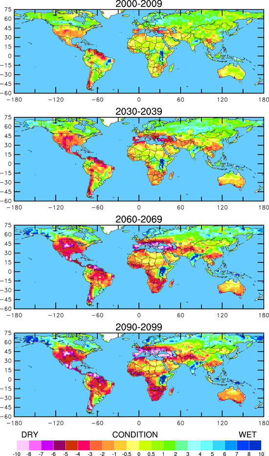
Whether or not this summer’s troubles blossom into the kinds of food riots and political instability seen in previous food crises remains an open question, but there is another unresolved issue with even greater potential long-term impact. With so many extreme weather events playing a role in this year’s high prices, many are wondering: To what extent is climate change a factor? And what might continued warming and increased CO2 mean for the long-term prospects of global food security? Are this summer’s stifling conditions “the new normal,” as the blog G-FEED has asked here and here?
One of the most significant recent developments in climate research is that scientists have begun linking individual extreme weather events to anthropogenic climate change. A groundbreaking 2011 study by the National Oceanic and Atmospheric Association, the UK Met Office, and others explained:
In the past it was often stated that it simply was not possible to make an attribution statement about an individual weather or climate event. However, scientific thinking on this issue has moved on and now it is widely accepted that attribution statements about individual weather or climate events are possible, provided proper account is taken of the probabilistic nature of attribution.
The report goes on to apply this principal to several extreme weather events from last year, including a devastating drought in Texas it claims was made 20 times more likely to occur by man-made climate change.
While no such study has yet examined the 2012 U.S. drought or other recent extreme weather events, most scientists believe that climate change is playing at least some role in this year’s freak weather episodes. “I think what we’re seeing is largely a naturally occurring event [influenced by La Niña weather patterns], but it’s occurring against the background of a warming environment,” Richard Seager, a professor and drought specialist at Columbia University’s Lamont-Doherty Earth Observatory, told Climate Central.
The idea of naturally occurring droughts playing out across a backdrop of global warming is a sobering one, because of the unique interactions between precipitation and hot weather. One timely study published last month describes how dry conditions increase the likelihood of abnormally hot weather: During droughts, less of the sun’s heat energy is used to evaporate moisture in vegetation and the soil, meaning that more energy can go into heating the air directly. Thus, “the occurrence probability of an above-average number of hot days is high after dry conditions and low after wet conditions.”
The study suggested that this phenomenon played an important role in exacerbating the 2011 Texas drought. Moreover, lead author Brigitte Mueller noted in an email conversation with Climate Central that precipitation in the 2012 U.S. drought was within the range where the drought/heat feedback would be expected to occur, “which implies an even higher likelihood for an above-average [number of hot days] to occur.”
With the planet expected to continue warming due to increasing levels of greenhouse gases in the atmosphere, and with reports from IPCC and National Center for Atmospheric Research predicting increasingly frequent droughts in the decades ahead, the heat/drought feedback loop is still more bad news for a global agricultural sector already tasked with the formidable job of feeding a world population expected to reach nine billion by mid-century.
Research on the effects that heat and drought have on crop yields and food production is beginning to emerge. One recent paper conservatively estimated that U.S. farm production could drop 4 to 13 percent over the next two decades or so. Another study, which considered “worst-case scenarios,” projected that average U.S. crop yields could plummet 63 to 82 percent by the end of the century if global warming is particularly rapid.
Such an outcome would necessitate fundamental changes in how the world is fed, and would obviously make global food security an issue of paramount importance. Even in the present, however, it seems clear that climate change is already an integral part of the food security issue. This summer’s freakish weather, in the United States and elsewhere around the globe, has brought the world closer to another round of food riots and political instability.
Although there are reasons to be optimistic that such a crisis may yet be averted in the short term, it appears that maintaining and improving global food security will remain a major challenge into the foreseeable future.
Sources: Bloomberg, Chatham House, Climate Central, The Financial Times, The Guardian, The Huffington Post, National Oceanic & Atmospheric Association, Proceedings of the National Academy of Sciences, Resources for the Future, Reuters, USDA.
Map Credit: U.S. Drought Monitor, courtesy of Mark Svoboda/National Drought Mitigation Center. Drought stricken corn on a farm in Iowa, which President Barack Obama and Agriculture Secretary Tom Vilsack visited on Monday, courtesy of the USDA. Future drought conditions, courtesy of Aiguo Dai/Wiley Interdisciplinary Reviews.
-
Population Aging: A Demographic and Geographic Overview
›The original version of this article, by Richard Cincotta, appeared on the National Intelligence Council’s Global Trends 2030 Blog. It is the first post in a series on population aging, featuring Jack Goldstone, Richard Jackson, Jennifer Dabbs Sciubba, Ronald Lee, Andrew Mason, Toshi Yoshihara, Elizabeth H Stephen, David Coleman, and Eric Kaufmann.
This series, Population Aging to 2030, begins with an introductory essay aimed at familiarizing readers with some of the demographic and geographic particulars of this phenomenon, and with several key demographic terms. The term most in need of definition is, of course, “population aging.” -
Michael Kugelman, Sustainable Security
The Global Land Rush: Catalyst for Resource-Driven Conflict?
›July 31, 2012 // By Wilson Center StaffThe original version of this article, by Michael Kugelman, appeared on SustainableSecurity.org.
On May 11, the UN approved new international rules to govern how land is acquired abroad. These Voluntary Guidelines (VGs), the outcome of several years of protracted negotiations, are a response to growing global concern that nations and private investors are seizing large swaths of overseas agricultural land owned or used by small farmers and local communities for food, medicinal, or livelihood purposes. FAO head Jose Graziano da Silva describes the VGs as “a starting point that will help improve the often dire situation of the hungry and poor.”
It’s hard to quibble with the intent of the guidelines. They call for, among other things, protecting the land rights of local communities; promoting gender equality in land title acquisition; and offering legal assistance during land disputes.
Unfortunately, however, any utility deriving from the VGs will be strictly normative. As their name states explicitly, they are purely optional. A toothless set of non-obligatory rules will prove no match for a strategy that is striking both for its scale and for the tremendous power of its executioners.
Oxfam estimates that nearly 230 million hectares of land (an area equivalent to the size of Western Europe) have been sold or leased since 2001 (with most of these transactions occurring since 2008). According to GRAIN, a global land rights NGO, more than two million hectares were subjected to transactions during the first four months of 2012 alone. One of the largest proposed deals – an attempt by South Korea’s Daewoo corporation to acquire 1.3 million hectares of farmland in Madagascar – failed back in 2009. Still, even larger investments are being planned today, including a Brazilian effort to acquire a whopping six million hectares of land in Mozambique to produce corn and soy (Mozambique offered a concession last year).
Continue reading on SustainableSecurity.org.
Sources: BBC, Food and Agriculture Organization, GRAIN, MercoPress, Oxfam, Reuters.
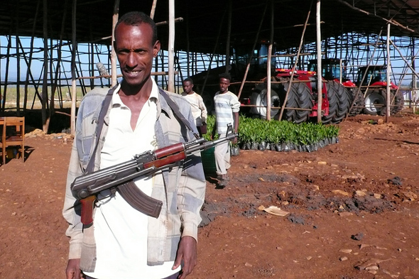
Photo Credit: “Garde armé,” courtesy of flickr user Planète à vendre. -
Chaotic Climate Change and Adaptation in Fragile States
›In “Chaotic Climate Change and Security,” published in the June issue of International Political Sociology, Maximilian Mayer traces the transformation of climate change from a long-term problem to something that has taken on a new urgency in recent years. Understanding the non-linear nature of climate change – the “abrupt changes” that can come as environmental thresholds are crossed – has led to the securitization of the environment, writes Mayer. Unfortunately, the “doomsday rhetoric of scientists and campaigners about ‘tipping points’ has apparently failed to spur governments toward negotiating a meaningful agreement.” Climate change skepticism still exists, he points out, and even those who are convinced of the potential negative impacts of environmental change on state security have failed to reverse detrimental actions, choosing instead to focus on ameliorating the effects of change on their individual states. As a replacement for these failed frameworks, Mayer suggests that actor-network theory should be used as it better accounts for the interconnected nature of climate change.Katherine Houghton discusses the relationship between climate change and resilience in her article “Climate Change in Fragile States: Adaptation as Reinforcement of the Fabric of the State,” published in a collection of articles written by members of the United Nations University Summer Academy. Houghton writes that in fragile states, environmental issues can be “compounded by armed conflict and institutional failure,” which further destabilizes the country. She mentions cases in which the state lacks the authority to properly assist its citizens following natural disasters, like the flooding of the Indus Valley in Pakistan’s Federally Administered Tribal Areas. In these cases, failure of the government to meet citizens’ needs “fuels instability and fragility rather than fosters resilience.” Any action to reduce the effects of climate change on residents of vulnerable areas must thus begin with the state, she writes. “Without effective action to strengthen the state and thereby enable adaptation, climate-induced adverse effects and extreme events may lead to the further destabilization of already fragile states.” -
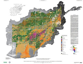
New USGS Report and Maps Highlight Afghanistan’s Mineral Potential, But Obstacles Remain
›Two maps released to the public for the first time this month illustrate the vast wealth of mineral deposits in the war-torn nation of Afghanistan. The maps, created through a joint effort from the U.S. Geological Survey and Department of Defense Task Force for Business and Stability Operations, are the first of their kind to provide large-scale coverage of a country using a technology called hyperspectral imaging, which measures the reflectance of material on the Earth’s surface simultaneously across a continuous band of wavelengths broken up into 10 to 20 nanometer intervals. More than 800 million individual pixels of data were collected during a period of 43 days in 2007 by a NASA aircraft. Each data point was then “compared to reference spectrum entries in a spectral library of minerals, vegetation, water, ice, and snow in order to characterize surface materials across the Afghan landscape.”
Two maps released to the public for the first time this month illustrate the vast wealth of mineral deposits in the war-torn nation of Afghanistan. The maps, created through a joint effort from the U.S. Geological Survey and Department of Defense Task Force for Business and Stability Operations, are the first of their kind to provide large-scale coverage of a country using a technology called hyperspectral imaging, which measures the reflectance of material on the Earth’s surface simultaneously across a continuous band of wavelengths broken up into 10 to 20 nanometer intervals. More than 800 million individual pixels of data were collected during a period of 43 days in 2007 by a NASA aircraft. Each data point was then “compared to reference spectrum entries in a spectral library of minerals, vegetation, water, ice, and snow in order to characterize surface materials across the Afghan landscape.”
Accompanying the release of the maps is a USGS study, completed in September of 2011, that largely confirms earlier reports from the DOD and USGS on the size of Afghanistan’s untapped mineral resources. The first reports received widespread media coverage last year, and updated estimates indicate that upwards of $900 billion worth of mineral reserves are present in a number of different forms including copper, iron, gold, and, most notably, more than one million metric tons of rare earth elements.
Scientists involved with the project believe that there may be even more reserves awaiting discovery. “I fully expect that our estimates are conservative,” said Robert Tucker from the USGS in an interview with Scientific American. “With more time, and with more people doing proper exploration, it could become a major, major discovery.”
Over the course of the study, scientists from the USGS and Afghan Geological Survey combined the newly-created spectral data with existing maps to identify 24 areas of interest (AOIs) that warranted hands-on investigation.
The two hyperspectral maps illustrate different parts of the electromagnetic spectrum. Shortwave infrared wavelengths reveal carbonates, phyllosilicates, and sulfates, while visible and near-infrared wavelengths show iron-bearing minerals, which yield products ranging from copper to rare earth elements and uranium. Each map classifies 31 different types of materials by color.
Although the hyperspectral maps only show mineral deposits on the surface, geologists were able to estimate what lies beneath by combining new data with samples previously taken from trenches, drill holes, or underground workings at the AOIs by Soviet and Afghan scientists. According to the USGS, “A number of the AOIs were field checked by USGS and DOD geologists between 2009 and 2011, and the previous geologic interpretations and concepts were confirmed.”
Actual Extraction: Not Easy
Afghanistan has been “scouring the globe for investors to develop its mines in an attempt to lift one of the world’s poorest nations out of misery through investment,” according to The Wall Street Journal. Contracts have already been awarded to China and India to develop copper and iron mines, respectively, and another round of bidding is currently in progress for four unexploited sites that are being closely eyed by countries such as the United States, Australia, and Turkey.
But significant hurdles remain in the quest to turn Afghanistan’s buried minerals into a steady source of income for the government and the Afghan people. Security is still a major concern and United States will pull out a vast majority of its combat troops by 2014. The government has established a Mines Protection Unit to guard sites where ground has already been broken, and plans to increase the size of the unit as necessary to provide security for all mining projects nationwide. For now the Afghan Ministry of Mines is only taking bids for projects in the more secure northern part of the country, where deposits of copper and gold are located. As the nation develops and stabilizes, massive resources of rare earth elements located in the notoriously volatile Helmand Province will open for bids.
Security isn’t the only factor affecting the country’s mining prospects. “If you want to do mineral resource development, there are two things you need to pay attention to: water and energy resources. Where is the power going to come from? You can’t develop these large mineral deposits without energy,” said director of the USGS program in Afghanistan, Jack Medlin, in an interview with EARTH magazine.
There are also the traditional pitfalls of developing extractive industries, especially in poor and conflict-prone countries, including corruption, inequity, land disputes, and environmental degradation. And the fact that Afghanistan is landlocked, making supply lines in an out of the country difficult (as the United States has discovered).
Despite the many hurdles, there is plenty of optimism for an Afghan future brightened by mineral wealth. The new data shows that previous reports of substantial resources were not far off, and the Afghan economy, which for years has relied on opium as its biggest export, could certainly use the help. “The prognosis is extremely encouraging and could play a significant role in recovery from decades of war,” USAID advisor Wayne Pennington told EARTH.
For the full resolution versions of the hyperspectral imaging maps (~90MB each) see here and here.
Keenan Dillard is a cadet at the United States Military Academy at West Point and an intern with the Woodrow Wilson Center’s Environmental Change and Security Program.
Sources: Afghan Geological Survey, Afghan Ministry of Mines, Christian Science Monitor, U.S. Department of Defense, EARTH, The New York Times, Scientific American, U.S. Geological Survey, The Wall Street Journal, World Bank.
Image Credit: USGS.
-
Urbanization and the Global Climate Dilemma
›Urbanization and climate change may be the two most important trends to shape global development in the decades ahead. On the one hand, urban cities have the potential to serve as engines of change, driving economic growth in some of the world’s least developed countries and pulling more people out of poverty than at any other time in history. On the other hand, climate change could undercut all of this by exacerbating resource scarcity and putting vulnerable communities at risk from sea level rise and more frequent and intense storms.
-
Visualizing Complex Vulnerability in Africa: The CCAPS Climate-Conflict Mapping Tool
›“Every crisis is complex, and the Sahel is no exception,” wrote USAID Assistant Administrator Nancy Lindborg in a recent Huffington Post article that called for “smarter programming and a coordivenated response” to chronic crises. “A regional drought has been overlaid with instability stemming from the coup in Mali and conflict in the northern part of that country where armed militant groups have forced the suspension of critical relief operations” and led to refugee movement into neighboring countries simultaneously challenged by drought and crop infestation. Understanding the complexity of this type of crisis, let alone visualizing the multiple factors that come into play, is a growing challenge for policymakers and analysts.
Enter version 2.0 of a mapping tool created by the Climate Change and African Political Stability Program (CCAPS) housed in the Robert S. Strauss Center for International Security and Law, based at the University of Texas, Austin.
In collaboration with the College of William and Mary, Trinity College, and the University of North Texas, and with funding by the U.S. Department of Defense’s Minerva Initiative, CCAPS originally launched the mapping tool in March of this year. The map is powered by mapping and data tools from Esri and allows users to view any combination of datasets on international development projects, national governance indicators, incidences of conflict, and climate vulnerability data.
With an intuitive interface and compelling visuals, the mapping tool is a valuable resource for policy analysts and researchers to assess the complex interactions that take place among these environmental, political, and social factors. Advanced filters allow the user to identify a subset of conflicts and aid projects and there are nine base map styles from which to choose.The mapping tool is anything but static. The team is constantly working to refine and enhance it through the inclusion of additional indicators and improvement of the interface. The updated version now includes CCAP’s new Social Conflict in Africa Database, which tracks a broad range of social and political unrest, and their partners’ real-time conflict dataset, the Armed Conflict Location and Event Dataset (ACLED), which tracks real-time conflict data. Impressively, the ACLED data will be updated weekly.
I asked CCAPS program manager Ashley Moran to clarify how the governance indicators work in the model. She explained:The national governance indicators are included in one of four baskets that make up the climate vulnerability model…and represent four potential sources of vulnerability: physical exposure to climate-related hazards, population density, household and community resilience, and governance and political violence. They used the term “basket” since most include several indicators that reflect the full dimensions of that source of vulnerability. The fourth basket includes five national governance indicators and one indicator of political violence.
Moran also shared plans to add more detailed national governance data to the map:We are developing a mapping tool specifically for the climate vulnerability model, which will allow users to see the component parts of the model. It will allow users to re-weight the baskets (e.g. if a user thought governance should have more weight within the model since the government response to climate hazards is key), and it will also allow users to examine an area’s vulnerability to just one or two baskets of the user’s particular interest (instead of all four baskets combined as the tool does now). When we launch this, a user will essentially be able to see the vulnerability model disaggregated into its component parts, so they’ll be able to map just the governance data in the model, if they want.
In the coming months, the CCAPS team will add more detailed historical and projected data on climate vulnerability, data on disaster response capacity, as well as international aid projects coded for climate relevance.
Each of these datasets on their own are a wealth of vital information, but understanding how they intersect and the potential impact of their interactions is crucial to improving our understanding of them individually and collectively and creating responses that are timely and long-lasting.
If you’re in the San Diego area next week, check out Ashley Moran’s presentation of the mapping tool at the Esri International User Conference and the Worldwide Human Geography Data Working Group.
Sources: The Climate Change and African Political Stability Program, The Huffington Post.
Image Credit: CCAPS
Showing posts from category security.