-
Managing the Planet: The World at Seven Billion
›
Population growth “is highly concentrated in what are today the poorest and least well-governed areas of the world,” said George Mason University professor Jack Goldstone at the Wilson Center on December 5.
Goldstone was joined by Suzanne Ehlers, president and CEO of Population Action International (PAI), and Matthew Erdman, population-health-environment technical advisor at USAID, to discuss the implications of seven billion people and counting for the environment as part of the joint Wilson Center-George Mason University Managing the Planet series. [Video Below]
-
Can Family Planning Save Millions From Malnutrition in a Warming World?
›
As the effects of climate change become increasingly apparent, existing poverty and human security challenges are being compounded. Among them, food security is one of the most pressing, especially in the developing world.
Based on a model developed by researchers at Futures Group, a pilot project in Ethiopia reveals that a lower fertility track for some countries could help compensate for the negative effects of climate change on agricultural yields. The study, conducted by MEASURE Evaluation and funded by USAID and The David and Lucile Packard Foundation, suggests incorporating family planning into existing climate change adaptation strategies.
-
Population and Environment in Saadani National Park, and Repositioning Family Planning in Sub-Saharan Africa
›Tanzania’s Saadani National Park is a hotbed of biodiversity and, like other national parks in the region, it’s surrounded by human activity. A report by the BALANCED Project, “Population, Health, Environment Situational Analysis for the Saadani National Park Area, Tanzania,” provides a snapshot of the population, health, and environment situation inside the park to serve as a baseline for future activities of the Tanzania Coastal Management Partnership (TCMP) – a joint initiative of the government of Tanzania, USAID, and the University of Rhode Island’s Coastal Resources Center. A behavioral monitoring system implemented in June 2009 used surveys that reached a total of 437 respondents (54 percent women) from eight villages to analyze the “behaviors that positively and negatively influence the utilization and condition of natural resources.” The surveys found that arable land is scarce, fisheries are being depleted, and people have inadequate access to healthcare, water, sanitation, fuel, and family planning resources. The results suggest a strong case for expanding TCMP’s existing integrated approach – combining HIV/AIDS, conservation, and livelihoods goals – to include promotion of positive behavior changes, particularly as they relate to family planning and the effects of population growth on biodiversity loss and resource depletion.
-
2012 Aid Transparency Index
›Publish What You Fund recently released its 2012 Aid Transparency Index, an annual review of 43 indicators assessing to what degree information about policies, strategies, and individual projects are published for public consumption by aid donors. These indicators include things like disclosing the type of aid given (e.g., grant, loan, export credit, debt relief), the quality of disclosure policies, and the online presence of centralized, public databases of all the organization’s activities.
-
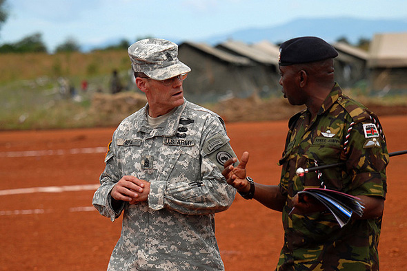
Should AFRICOM Leave Development to the Professionals?
›August 30, 2012 // By Schuyler NullSince its inception, there’s been a great deal of prognostication about the role and goals of the U.S. military’s newest regional command, AFRICOM. The smallest of the six regional commands, in terms of staff and budget, its objectives have included traditional roles like building local military capacities, confronting transnational threats (terrorism, weapons of mass destruction, small arms, drugs, etc.), and helping to mitigate violent conflicts, but also more development-oriented goals, like fighting HIV/AIDs and malaria, “strengthening democratic principles,” and “fostering the conditions that lead to a peaceful, stable, and economically strong Africa.”
-
Geoff Dabelko on the Evolution of Integrated Development and PHE
›August 27, 2012 // By Schuyler Null“Population-health-environment [PHE] connections have really been a focus of ours here at the Wilson Center for the last 15 years,” said outgoing ECSP Director Geoff Dabelko in an interview at the Wilson Center. The goal of ECSP’s project – HELPS (health, environment, livelihoods, population, and security) – is “really trying to understand these issues together.”
-
Open Data Initiatives at USAID Reflect Move Towards Collaboration, Enabling Efforts
›Over the past year and a half, USAID has been busy reinventing itself. The announcement of its USAID FORWARD initiative and the release (jointly, with the State Department) of the first Quadrennial Diplomacy and Development Review in late 2010 signaled significant changes for the organization, including several reforms designed to modernize operations and improve transparency. Part of that effort is making data collection and dissemination more open.
Thus far, the results have been encouraging.
September of last year saw the launch of an awareness campaign focused on the Horn of Africa, co-sponsored by the Ad Council and called, somewhat confusingly, USAID FWD (famine, war, drought). As part of the program, USAID published a collection of regional maps, aggregating the organization’s substantial data pool and showing everything from food and water security to the movement of refugees and IDPs (internally displaced persons).
Using data from its own FEWS.NET site, USAID created the maps with open-source tools, allowing other organizations and concerned individuals to leverage the data for additional aid and outreach activities. Many, including the ONE Campaign and InterAction, were quick to incorporate the maps and underlying data into their own activities.
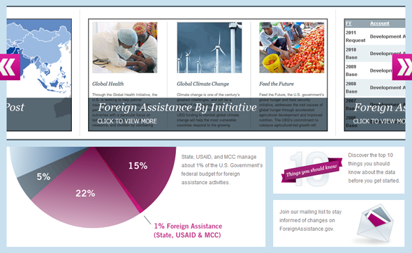
In order to promote greater data access and transparency, USAID also collaborated with the Department of State to create the Foreign Assistance Dashboard, a website that provides sortable aid budget allocation data to the general public. Launched in late 2010 with frequent updates since, the site allows users to see easily how aid is apportioned by region, sector, initiative, or other categories.
For instance, visitors can see that USAID more than quadrupled its humanitarian assistance to Pakistan in 2010 as a result of that country’s devastating flooding. Aid then fell back to near 2009 levels the following year.
Recently, USAID has also taken its open data efforts to the Web. Faced with 117,000 records of development loans provided by its own Development Credit Authority and lacking proper geographic coding, the organization undertook a pioneering experiment in crowdsourcing this June. Civilian volunteers from the online technical communities GISCorps and the Standby Task Force pitched in to help code the data, as did unaffiliated citizens attracted by social media campaigns.
The end results were outstanding: the volunteers finished the job in just 16 hours, although USAID had initially expected the operation to take 60.
Representatives from USAID recently published an illuminating case study about the crowdsourcing experiment and launched it at the Wilson Center. “By leveraging partnerships, volunteers, other federal agencies, and the private sector, the entire project was completed at no cost,” the report noted, adding that USAID hoped to have “blaze[d] a trail to help make crowdsourcing a more accessible approach for others.” One of the case study authors, Shadrock Roberts, noted that “we need to be working as hard to release relevant data we already have as we are to create it.”
USAID’s recent experiments with transparency and greater civilian participation appear to be part of a larger organizational shift toward greater openness and collaboration. Administrator Rajiv Shah seemed to confirm this in a March interview with Foreign Policy, when he spoke at length about the benefits of partnering with the private sector as well as other NGOs.
The recently reported demise, or at least great diminishing, of President Obama’s Global Health Initiative (GHI), which closed its doors amid a heated turf battle between USAID, the State Department, and PEPFAR, lends credence to this theory as well. The official GHI blog stated last week that it would “shift focus from leadership within the U.S. Government to global leadership by the U.S. Government.” This appears to indicate greater future emphasis on collaboration, with an eye toward enabling non-USAID actors to play a greater role in the development process.
It remains to be seen how USAID’s role and strategy will change over the next few years. However, results from the organization’s initial attempts at open data and open government policies have been positive in many respects, and there is reason to hope they will continue to push the boundaries in these areas.
Sources: Center for Global Development, Foreign Assistance Dashboard, Foreign Policy, Global Health Initiative, USAID.
Image Credit: Foreign Assistance Dashboard. -
Visualizing Complex Vulnerability in Africa: The CCAPS Climate-Conflict Mapping Tool
›“Every crisis is complex, and the Sahel is no exception,” wrote USAID Assistant Administrator Nancy Lindborg in a recent Huffington Post article that called for “smarter programming and a coordivenated response” to chronic crises. “A regional drought has been overlaid with instability stemming from the coup in Mali and conflict in the northern part of that country where armed militant groups have forced the suspension of critical relief operations” and led to refugee movement into neighboring countries simultaneously challenged by drought and crop infestation. Understanding the complexity of this type of crisis, let alone visualizing the multiple factors that come into play, is a growing challenge for policymakers and analysts.
Enter version 2.0 of a mapping tool created by the Climate Change and African Political Stability Program (CCAPS) housed in the Robert S. Strauss Center for International Security and Law, based at the University of Texas, Austin.
In collaboration with the College of William and Mary, Trinity College, and the University of North Texas, and with funding by the U.S. Department of Defense’s Minerva Initiative, CCAPS originally launched the mapping tool in March of this year. The map is powered by mapping and data tools from Esri and allows users to view any combination of datasets on international development projects, national governance indicators, incidences of conflict, and climate vulnerability data.
With an intuitive interface and compelling visuals, the mapping tool is a valuable resource for policy analysts and researchers to assess the complex interactions that take place among these environmental, political, and social factors. Advanced filters allow the user to identify a subset of conflicts and aid projects and there are nine base map styles from which to choose.The mapping tool is anything but static. The team is constantly working to refine and enhance it through the inclusion of additional indicators and improvement of the interface. The updated version now includes CCAP’s new Social Conflict in Africa Database, which tracks a broad range of social and political unrest, and their partners’ real-time conflict dataset, the Armed Conflict Location and Event Dataset (ACLED), which tracks real-time conflict data. Impressively, the ACLED data will be updated weekly.
I asked CCAPS program manager Ashley Moran to clarify how the governance indicators work in the model. She explained:The national governance indicators are included in one of four baskets that make up the climate vulnerability model…and represent four potential sources of vulnerability: physical exposure to climate-related hazards, population density, household and community resilience, and governance and political violence. They used the term “basket” since most include several indicators that reflect the full dimensions of that source of vulnerability. The fourth basket includes five national governance indicators and one indicator of political violence.
Moran also shared plans to add more detailed national governance data to the map:We are developing a mapping tool specifically for the climate vulnerability model, which will allow users to see the component parts of the model. It will allow users to re-weight the baskets (e.g. if a user thought governance should have more weight within the model since the government response to climate hazards is key), and it will also allow users to examine an area’s vulnerability to just one or two baskets of the user’s particular interest (instead of all four baskets combined as the tool does now). When we launch this, a user will essentially be able to see the vulnerability model disaggregated into its component parts, so they’ll be able to map just the governance data in the model, if they want.
In the coming months, the CCAPS team will add more detailed historical and projected data on climate vulnerability, data on disaster response capacity, as well as international aid projects coded for climate relevance.
Each of these datasets on their own are a wealth of vital information, but understanding how they intersect and the potential impact of their interactions is crucial to improving our understanding of them individually and collectively and creating responses that are timely and long-lasting.
If you’re in the San Diego area next week, check out Ashley Moran’s presentation of the mapping tool at the Esri International User Conference and the Worldwide Human Geography Data Working Group.
Sources: The Climate Change and African Political Stability Program, The Huffington Post.
Image Credit: CCAPS
Showing posts from category USAID.