-
Renewable Resource Shocks and Conflict in India’s Maoist Belt
› India’s Maoist (or “Naxalite”) insurgency has resulted in more than 9,000 deaths in the last decade and famously been called the country’s “single biggest internal security challenge” by Prime Minister Manmohan Singh. In, Renewable Resource Shocks and Conflict in India’s Maoist Belt, a working paper for the Center for Global Development, Devesh Kapur, Kishore Gawande, and Shanker Satyanth present their econometric analysis of the conflict and suggest that there is a link with natural resource depletion.
 -
Janani Vivekananda on Strengthening Resilience to Climate Variability in South Asia
›
“Building resilience should help address the root causes of vulnerability, creating increased capacity to be able to adapt to a range of possible climate futures, not just cope with… specific climate impacts,” says International Alert’s Janani Vivekananda. Otherwise, if the specific impacts don’t play out, “in a fragile context that could be quite destabilizing and seen as a wasted opportunity.”
-
Strengthening Responses to Climate Variability in South Asia
›Climate change and conflict can create a self-reinforcing feedback loop: Climate change exacerbates existing conflicts, while conflict makes adapting to climate change more difficult, said Janani Vivekananda of International Alert at the Wilson Center on February 7. [Video Below]
-
A Year for Cooperation, Not Conflict, Over Water
›February 12, 2013 // By Kate DiamondYou might think that conflict over water is inevitable as rising temperatures and changing climates are expected to constrain supplies in the coming decades at the same time that expanding consumption standards and growing populations are expected to boost demand. But you’d be wrong, according to the United Nations – and they’re launching the International Year for Water Cooperation this week to make that point.
-
Kagondu Njagi, AlertNet
In Kenya, Water Stress Also Breeds Cooperation Between Competing Groups
›January 29, 2013 // By Wilson Center StaffThe original version of this article, by Kagondu Njagi, appeared on Thomson Reuters’ AlertNet.
By the time the violence had died down, more than 80 people lay dead and hundreds were left homeless.
Yet there was scarcely enough water – the resource the Maasai and Kikuyu tribes were fighting over – to wash away the blood that had stained this part of Kenya’s Rift Valley.
-
Planning for Complex Risks: Environmental Change, Energy Security, and the Minerva Initiative
›2012 witnessed a remarkable number and extremity of environmental conditions, from Hurricane Sandy and the U.S. drought to wildfires in Siberia and drought-driven blackouts in India. Arctic sea ice melted to its furthest extent in recent history. The energy landscape continued to change as well, from the launch of the U.S. Navy’s Great Green Fleet to the first liquefied natural gas shipments across the Arctic. As President Obama clearly stated in his second inaugural address, climate change is heightening both our risks and the need to respond, but tying together all of these issues is a highly complex endeavor.
-
Migration Flows, New Growth Demand New Ways to Do Urban Development
›A majority of the world population now lives in urban settings, but many of the most rapidly growing cities are unprepared to accommodate their new citizens. Newly swollen municipalities in poor and institutionally fragile countries are especially disadvantaged by poor planning and management, deficient public services, and citizen insecurity.
-
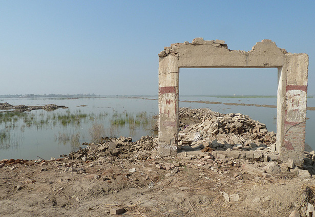
Environmental Migration, Security, and Climate Change
›“Environmental degradation has measurable impacts on migration and presents humanity with unprecedented challenges,” writes Laurence Turbiana in The State of Environmental Migration, edited by François Gemenne and Pauline Brücker of the Institute for Sustainable Development and International Relations and Dina Ionesco of the International Organization for Migration. The report presents the findings of students at the Paris School of International Affairs who examined a number of case studies in 2011, including sudden disasters like the floods in Thailand, Colombia, China, and Bangladesh, as well as slower-onset events like droughts in Somalia and Mexico. The editors conclude that “environmental migration, in its forced and voluntary forms, is a reality.”
Showing posts from category environmental security.