-
Top 10 Posts for November 2012
›Population and environment stories nearly swept the top 10 last month (ranked by unique pageviews). Sean Peoples’ first short film on population, health, and environment projects in Tanzania led the charge, followed by a guest post from Tim Tear and Craig Leisher of The Nature Conservancy; Ken Weiss’ Beyond Seven Billion event; Elizabeth Leahy Madsen’s look at Yemen’s demography; Kathleen Mogelgaard’s post on next steps for incorporating population dynamics in climate change; and a summary of Joel Cohen’s 45-minute YouTube introduction to demography for the Floating University.
-
Water Scarcity, Agriculture, and Energy Are Focus of ‘Choke Point: China Part II’
›With the start of part two of Circle of Blue and the China Environment Forum’s Choke Point: China series, the focus has broadened from looking more narrowly at water scarcity and energy to including the effects of food security and pollution in China too.
“From an environmental point of view,” said Circle of Blue Senior Editor Keith Schneider, the question is, “can a nation that big, operating at such a scale maintain its sustainability?”
-
The Land Matrix Visualizes Ebbs and Flows of Global “Land Grabs”
›
Over the past few years, large-scale acquisition of land by foreign or domestic firms, be they public or private, have been making headlines. But although these “land grabs” have received a great deal of attention, their details remain largely unknown. Which countries are the primary investors? Which are the main targets? What is the land used for?
-
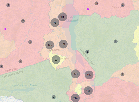
CCAPS Looks to Map Climate-Related Aid in Africa
›
Adapting to the effects of climate change is increasingly becoming an important component of many international development efforts. But how that integration occurs and what it looks like is an open question. To help answer that, the Climate Change and African Political Stability Program (CCAPS) at the University of Texas at Austin recently released a new database that for the first time tracks all the climate-related aid in one country – Malawi.
-
Climate Change’s Health Impacts, and the Rights-Based Argument for Family Planning
›UNFPA’s recently released State of World Population 2012 brings family planning to the center of the development debate. “There is indisputable evidence that when family planning is integrated into broader economic and social development initiatives, it can have a positive multiplier effect on human development and the well-being of entire nations,” the authors write. The report employs a rights-based approach to make the case for universal access to family planning – a goal which we are far from as 222 million women from the developing world currently have an unmet need for modern contraceptives. Meeting this need and improving quality of reproductive healthcare elsewhere would cost an additional $4.1 billion a year, but save approximately $5.7 billion in maternal and newborn health services. Other recommendations include increasing financial support and political commitment to ensure that family planning is of high quality, reducing the number of unintended pregnancies and abortions, including emergency contraception in family planning services, and engaging boys and men. -
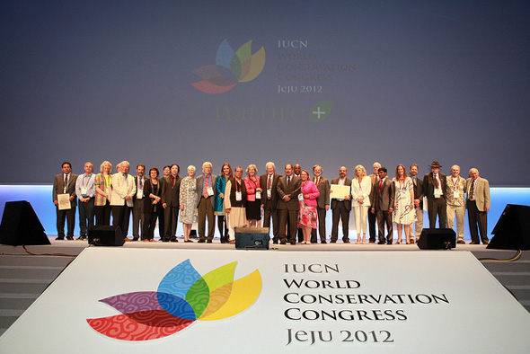
Linking the Environment and Women’s Health at the World Conservation Congress
›November 30, 2012 // By Payal ChandiramaniPeople don’t often think of gender issues when they think of the environment, but in fact sustainable development in many of the world’s most bio-diverse regions has a lot to do with women’s health and well-being.
At this year’s World Conservation Congress, where the theme was improving the inherent resilience of nature, ECSP’s Sandeep Bathala presented alongside Blue Ventures’ Gildas Andriamalala about the connections between women’s health and the environment – specifically on the potential of population, health, and environment (PHE) approaches as an effective sustainable development strategy.
-
Considering “Soft Geoengineering”
›Even as the climate debate has been paralyzed by politics, the concept of geoengineering has been in the news lately, most notably in October when Russ George dumped 120 tons of iron particles into the Pacific Ocean in a scheme to try and score carbon credits. Earlier this month, the Wilson Center’s Science and Technology Innovation Program hosted an event taking a look at “soft geoengineering” – techniques that might have low or minimal environmental side effects but still address or reverse climate change.
-
‘The Global Farms Race’: Comprehensive Study of Large-Scale Land Acquisitions Launches at Wilson Center
›Last month, Oxfam made an extraordinary request. It asked the World Bank to freeze its investments in agricultural land.
At a time when urbanization and growing service industries are bringing great neglect to agricultural sectors across much of the developing world, why would Oxfam want the World Bank to suspend its generous levels of agricultural funding?
 A Publication of the Stimson Center.