
Showing posts from category Eye On.
-
Brookings’ “Taking Stock of the Youth Challenge in the Middle East”
›Samantha Constant and Mary Kraetsch of the Brookings Institution have created a handy visual aid to understanding the Middle East’s demographics. The interactive flash graphic shows select economic and demographic information as you scroll over each country, including GDP per capita, youth percentage of the population, secondary school enrollment rate, and unemployment figures. Clicking on each country brings up a more detailed fact sheet that breaks down economic, education, and demographic statistics.
The companion write-up to the map stresses the importance of these figures to youth-inclusive development. Citing the 2009 UN Arab Human Development Report, the authors point out that the region will need to create about 51 million jobs by 2020 to account for youth entering the work force and already high unemployment rates.
The report does however shy away from some of the Middle East’s most difficult demographic challenges. Iraq and the West Bank are mentioned as areas that will continue to have large youth bulges, but Yemen, which has far and away the most troubling demographics in the region, is not mentioned at all. Adding “total fertility rate” as a statistic, which shows the average number of children born to an average woman over her lifetime, might illustrate these trouble areas more clearly. As illustrated by data from the Population Reference Bureau, Yemen (5.5), the Palestinian Territory (4.6), and Iraq (4.4) all have noticeably higher total fertility rates than other countries in the region, which helps explain why their demographic problems will continue.
The inclusion of total fertility rates would also help make a stronger argument for closer attention to be paid to women’s rights issues, as generally better women’s rights translates to lower total fertility rates, which help draw down youth bulges over time. The report only briefly mentions that more research is needed to create better paths for young women to become productive members of society with “greater career opportunities beyond traditional roles.”
The map does mention that information will be updated on a regular basis so it is worth checking back to see what it added to this useful primer.
Sources: The Brookings Institution, Population Reference Bureau.
Interactive Map: “Understanding the Generation in Waiting” courtesy of The Brookings Institution. -
Natural Resource Frontiers at Sea
›
As burgeoning populations and growing economies strain natural resource stocks around the world, countries have begun looking to more remote and difficult-to-access resources, including deep-sea oil, gas, and minerals. The UN Convention on the Law of the Sea (UNCLOS) guarantees exclusive access to these resources within 200 nautical miles of a nation’s sovereign territory – called an exclusive economic zone (EEZ). TD Architects’ “Exclusive Economic Zone” illustrates this invisible global chessboard and highlights some examples of disputed areas, such as the South China Sea, the Mediterranean, the Falkland/Malvina Islands, and the Arctic.
-
Voices of World Water Day: Water and Health
›“Inadequate access to water supply, sanitation, and hygiene cause the deaths of over 1.5 million children each year,” Secretary of State Hilary Clinton said at the National Geographic Society and Water Advocates’ “World Water Day 2010” event. Her address marked a warmly welcomed recognition by the U.S. government of the strong connections between water and health.
“Voices of World Water Day” is a video capturing highlights of the discussion on water and health. Created by PATH and Water Advocates, it seeks to keep the messages and momentum from World Water Day alive and to share them with others.
Importantly, Clinton was not alone in her recognition, and her sentiments were widely shared among the event participants representing both the public and private sectors. Congressmen, Clarissa Brocklehurst of UNICEF, and William Asiko of the Coca-Cola Africa Foundation – to name a few – all weighed in on the necessity of clean, available water for public health. -
Visualizing Human and Natural Resources
›In the policy world, statistics, percentages, and budgets on the order of millions and billions are routinely thrown around. But what do six and a half billion people, 957 tonnes per second, or three trillion dollars really look like?
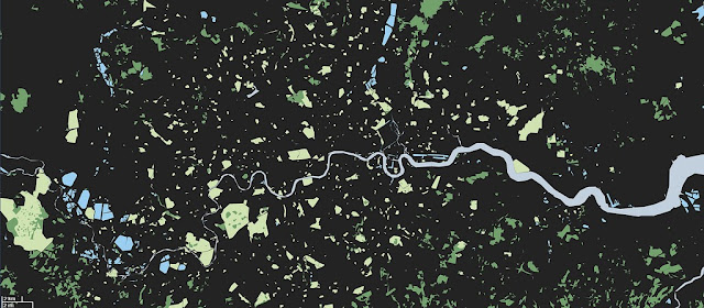
A visualization of London’s natural resources – grass, trees, and water only – by Adam Nieman.
Visual artist Adam Nieman recently received attention from The New York Time’s Dot Earth Blog for his illuminating scale models of hard-to-envision quantities such as the volume of oil being leaked from the Deepwater Horizon wells, global carbon emissions as measured in “UN Building units per second,” and the relatively small amount of air and water on Earth.
Demographers and sustainability experts often warn about the increasingly smaller allotment of natural resources per capita, but few have illustrated that reality at such a human scale as Nieman does.On a global level, Nieman’s work shows the tremendous population density of the world’s “urban island.” Over half of the global population now lives in cities, which is represented by the grey dot, just 616 km across in “Land-Cover Islands.”
Others seeking to improve quantitative visualizations include David McCandless of the site Information Is Beautiful. Among other things, McCandless has tackled the daunting task of accurately comparing spending in an age of trillion dollar budgets, with his “Billion Dollar Gram.”
Another group, the Dutch firm TD Architects, highlights the disparity between global demographics and the distribution of wealth with “Walled World.”
Nieman’s blog examines the confusion that often occurs at the interface between the political and scientific worlds. This confusion is amply demonstrated by debates over contentious issues such as budget priorities, population growth, and climate change.
Politicians often ask that complex problems be distilled into simple bullet points for speeches and policy documents. However, when it comes to problems of such complexity and scale, pictures like these may be worth a thousand bullet points.
Sources: New York Times, Reuters.
Photo Credit: “Green London (wide)” and “land cover islands” courtesy of flickr user JohnJobby. -
USAID Launches GeoExplorer: Connecting Natural Resource Management Activities, Practitioners, and Communities
›Part of USAID’s FRAMEweb community, GeoExplorer is a visual aggregator of natural resource management (NRM) activities, best practices, success stories, and lessons learned. As of launch, GeoExplorer is home to 43 activities, each searchable by scale (e.g. local, national, or regional), sub-sector (e.g. forestry, water, wildlife), and topic (e.g. governance, livelihoods, and health).
GeoExplorer was designed to foster knowledge sharing among and between practitioners, program managers, and researchers. USAID expects the tool to help avoid cases both of repeating past mistakes and reinventing the wheel, serve as a guide for study trips to the field, build community exchanges, and foster networking. It is built on ArcGIS architecture that USAID hopes will allow for continual expansion, particularly through the addition of GIS layers that can empower users with greater search options and tools for cross-project analytic analyses.
All activities on GeoExplorer are directly uploaded by users and USAID funding is not a requirement for inclusion. A FRAMEweb account (free) is all that is needed to sign-up and start adding your own projects. USAID hopes to make GeoExplorer available to host other NRM sub-sectors and even non-NRM activities in the future. -
Want to Model Climate Change? There’s an App for That
›C-Learn, developed by the coalition group Climate Interactive, is a three-region climate simulator that allows users to input targets for fossil fuels emissions, emissions from deforestation, and reductions from afforestation. The app then outputs the expected results for atmospheric CO2 concentrations and global temperature. The simulator is a free, public version of the more complicated C-ROADS, a tool designed to help policymakers compare the predicted effects of particular climate change mitigation policies.
Although interesting, C-Learn notably lacks the option to input assumptions regarding population growth rates, let alone those concerning more nuanced factors such as age structure, urbanization rates, or household size, the importance of which were recently discussed at the Wilson Center by the National Center for Atmospheric Research‘s Brian O’Neill. Population is a significant factor in determining what can be expected as reasonable emission targets and the failure to include space for demographic assumptions is a significant short-coming. -
SOUTHCOM Takes Disaster Response to Google
›United States Southern Command (SOUTHCOM) has publicly released a Google Earth-based mapping system, 3D User Defined Operational Pictures (UDOP) (Google Earth plug-in required), aiming to help emergency personnel and donors better respond to humanitarian crises.
Currently, UDOP maps are available for responses in Haiti and Chile. Data layers uploaded by SOUTHCOM and others can be toggled on and off and depict an array of information, from earthquake intensity maps to a 3D model of Haiti’s collapsed presidential palace. Other layers mark:
Although intriguing, the mapping system currently has major shortcomings: much of the information provided is out of date rather than in real time, and while some maps include information such as the structural integrity of buildings, patient capacities of hospitals, and brief status updates on site activities, others offer little more than approximate locations and names.- Locations and statuses of hospitals;
- Collapsed or blockaded sections of major roadways;
- Helipads and airstrips;
- Food and water distribution centers;
- IDP shelters; and
- Areas of gang activity.
Haiti and Chile, however, were only the first tests of the UDOP system. Given that the distinction between real-time and frozen data is blurred during days immediately following a disaster (the period for which UDOP is designed and most needed) and that the donor and humanitarian assistance communities will likely develop greater familiarity and comfort with the system over time, UDOP’s current flaws may simply reflect the system’s recent adoption.
For more on Google’s contributions to environmental work and human security, check out our previous post on educational climate change “tours” in Google Earth. -
The Plight of Urban Refugees in Nairobi
›“The Traditional image of life in tented sprawling camps no longer tells the full refugee story.”– Hidden and Exposed: Urban Refugees in Nairobi, Kenya
Coinciding with the end of UN-HABITAT’s 5th World Urban Forum, a new report and associated video, Hidden and Exposed: Urban Refugees in Nairobi, Kenya, have been released by the Humanitarian Policy Group (HPG) at the Overseas Development Institute (ODI) and the International Rescue Committee (IRC).
Hidden and Exposed removes the cloak of migration stereotypes and provides an unfiltered look at urban migrants’ struggle for daily survival. Focusing on seven neighborhoods with high refugee concentrations in Nairobi, the authors — through qualitative interviews and secondary data — found a unique, challenging urban environment for thousands of refugees. Aid and development groups often overlook these urban refugees, instead favoring work with traditional established camps on the urban periphery.
The HPG found that Nairobi’s 46,000 registered refugees represent a diverse mix of ethnic groups and nationalities, all trying to secure economic independence and security. While much research has been devoted to the traditional concept of displaced migrants in centralized ex-urban camps, such as Dadaab in Eastern Kenya, urban dwellers are just as vulnerable to insecurity, poverty, and harassment. With nebulous legal rights, facing discrimination and protected by only fragile support systems, the refugee community in Nairobi finds itself in a precarious situation.
In light of the challenges, the research team at HPG offered three basic recommendations as initial steps:
1. Protection:
2. Livelihoods:- Address confusion over legal rights to prevent issues of police harassment and community violence.
- Target a subset of donor funds for training local police forces and government agencies.
- Establish partnerships between the UNHCR and the Kenyan government to improve the latter’s Refugee Status Determination System.
- Funnel humanitarian and development aid toward legal aid services while also using innovative strategies to increase dialogue between urban refugees and the surrounding Kenyan communities.
3. Service Delivery:- Carry out surveys to better understand the Nairobi urban economy, including the informal sector.
- Support the government of Kenya in their efforts to help urban refugees to become self-reliant.
- Recognize the transition of refugees from sequestered camps to urban areas and develop an effective response.
- Secure Kenyan government permission for the issuance of work permits for refugees.
Fleeing conflict and attracted by the possibility of better jobs, services, or security, thousands of refugees have sought new lives in Nairobi. Yet the reality for many urban migrants is an existence burdened with inadequate assistance, a precarious legal status, and economic and physical insecurity. Through the implementation of these recommendations, HPG hopes to draw attention to these hidden refugees, and offer them the hope of improved livelihoods and effective security.- Design aid models to address the unique challenges faced by urban refugees in Nairobi.
- Ensure coordinated and comprehensive services, in conjunction with the Kenyan government and international organizations, to address the needs of the urban refugees and the surrounding communities, with particular attention granted to refugee women and girls.


