-
Tracking This Year’s Extreme Weather
›“Over the past several months, extreme weather and climate events seemed to have become the norm rather than the exception,” writes Kelly Levin for the World Resources Institute (WRI). Indeed, records have been broken around the world as countries experience unprecedented heat, drought, flooding, or other types of severe weather. And people are starting to take notice. A number of recent stories try to make sense of this wild weather and what, if anything, it has to do with climate change.
-
Al Jazeera Maps Water Flashpoints Around the World
›Historically, the concept of “water wars” – inter-state wars fought solely over water – has been fairly unsubstantiated. But continued population growth, accelerating development, and environmental changes are making water more scarce and in turn increasing the chances of related tensions and violence. To illustrate the growing role water plays in tensions around the world, Al Jazeera has put together a map linked to a series of stories they’ve done on water “flashpoints.”
-
Counting the World: UNFPA Highlights the Challenges of Census-Taking
›The United Nations biannual population projections are some of the most (if not the most) widely used numbers in demography. Researchers and policymakers alike rely on the figures to plan for present and future challenges. But few consider the story behind the statistics. Where does the data come from? The United Nations Population Fund (UNFPA) recently released a short documentary on conducting censuses in challenging environments, with a spotlight on Indonesia, Chad, the Palestinian Territories, Belarus, and Bolivia.
-
Stress Levels of Major Global Aquifers Revealed by Groundwater Footprint Study
›
In the “first spatially explicit comparison of groundwater use, availability, and environmental flow for aquifers globally,” a new article in Nature finds that the “size of the global groundwater footprint is currently about 3.5 times the actual area of aquifers.” An aquifer’s footprint is the theoretical size it would need to be to sustainably support use at its current rate, so groundwater footprints being much larger than their corresponding aquifers is a sign of overuse.
-
Hans Rosling on Religion, Babies, and Poverty
›“I’m going to talk about religion. But it’s a broad and very delicate subject, so I have to limit myself. Therefore I will limit myself to only talk about the links between religion and sexuality…I will talk on what I remember as the most wonderful – it’s the moment when the young couple whispers, ‘tonight, we are going to make a baby,’” said Hans Rosling, the eclectic Swedish doctor and statistician known for his Gapminder tool, in a TedxSummit presentation in April.
-
PRB’s 2012 World Population Data Sheet
› “The most rapid population growth in many ways [occurs in] the countries that can least afford it,” said Carl Haub in a webinar on July 19 to launch the Population Reference Bureau’s (PRB) 50th annual World Population Data Sheet. This year, the report explores aging populations in more developed countries, rapid population growth in less developed countries, and the increased global prevalence of non-communicable diseases in an interactive map, which concisely illustrates global trends. PRB estimates that the world’s population is 7,057,075,000 as of mid-2012; the global population crossed the seven billion threshold in October 2011.
 “The most rapid population growth in many ways [occurs in] the countries that can least afford it,” said Carl Haub in a webinar on July 19 to launch the Population Reference Bureau’s (PRB) 50th annual World Population Data Sheet. This year, the report explores aging populations in more developed countries, rapid population growth in less developed countries, and the increased global prevalence of non-communicable diseases in an interactive map, which concisely illustrates global trends. PRB estimates that the world’s population is 7,057,075,000 as of mid-2012; the global population crossed the seven billion threshold in October 2011.
Aging Europe and East Asia
Haub explained that population growth in Europe has been declining since the 1970s and is more or less a “pre-programmed destiny” for these countries. People of child-bearing ages make up a smaller percent of the population in many more developed countries, so unless there is an “enormous increase” in total fertility rates, these populations will continue to decline for the foreseeable future.
Haub noted that these aging populations are unprecedented. In Germany and Italy, for example, 21 percent are over the age of 65; many other European countries have similar figures, as do other developed countries like Japan and South Korea. PRB expects these percentages to increase throughout the next century and for European countries to struggle to support greater numbers of retirees.
Many such states have already found it difficult to raise the retirement age, even though medical advances allow people to work until later ages. PRB projects that in Japan, 42 percent of their population will be over the age of 60 in 2050; if such a large percentage of the population is no longer in the labor force, it will be difficult for to find the resources to support them.
The report shows that the United States, on the other hand, is still experiencing modest population growth. The higher birthrate is in part due to immigration, as recent immigrants to the United States tend to have more children. Haub noted that European states have been reluctant to accept greater numbers of migrants to try to reverse their declining population.
Youthful Developing Countries
While the demographic destiny of aging countries is somewhat determined, the future for less developed countries is more uncertain. Many countries in sub-Saharan Africa, the Middle East, and South Asia have large and growing youth populations, and how many children these “future parents” will have is uncertain. That uncertainty is underscored by the variety of scenarios for future population growth. The UN has four variants – high, medium, low, and constant fertility – which vary considerably in their projections for future populations, and PRB’s global projections for 2050 are some 600 million people more than the commonly-used medium variant UN projection.
Rapid growth in the least developed countries is hardly a new phenomenon, but PRB breaks down the numbers to an impressive degree. The 2012 Data Sheet provides updated net migration rates, projected population as a multiple of today’s, infant mortality rates, rate of natural increase, and other basic statistics. PRB also provides population pyramids from the wealthiest and poorest quintiles of the population of Malawi, as an example of the utility of desegregating data to better allocate resources to the underserved. They found that while birthrates have begun to decline for the wealthiest one-fifth of Malawians, the poorest citizens still have a total fertility rate of over seven children per woman.
Measuring Health Systems
Devastating infectious diseases – malaria, tuberculosis, and HIV/AIDS – have long been entrenched in some of the least developed and most rapidly growing parts of the world. But this year, PRB began to assess health on a broader level by tracking deaths attributed to non-communicable diseases as well. Diseases like cardiovascular disease, diabetes, respiratory illness, and cancer are leading causes of death in developed countries, but they have also increased in prevalence in developing countries at an alarming rate.
PRB is not the only organization to take note of the change in disease predominance. The World Health Organization has issued guidelines targeting four factors which increase the risk of these illnesses: tobacco use, alcohol abuse, poor diet/obesity, and physical inactivity. The UN also called a special session last September to discuss non-communicable diseases. President of PRB Wendy Baldwin noted that the last such discussion on a health issue was 10 years ago about HIV/AIDS.
Baldwin also pointed out that non-communicable diseases can increase the burden on the health systems of developing countries even more so than in developed states. She reported that in south Asia, for example, people have heart attacks on average six years earlier than people in developed countries, meaning more families lose their primary breadwinners.
The risk factors for these non-communicable diseases are difficult to target, especially with increasing urbanization in developing countries. But in a video accompanying the report, Baldwin mentioned that raising the price of cigarettes is an effective way to reduce tobacco consumption, especially for youth. Some countries have also made progress in increasing physical activity through sports programs and making urban areas safer for pedestrians. “The low and middle income countries have a real opportunity to take really positive steps to confront that rise in non-communicable diseases and to address the risk factors that drive them,” she said.
The Data Sheet Over Time
The World Population Data Sheet has long been a vital resource for those in the population, health, and environment fields and has grown to include far more data than its first iteration in 1962. At first, the sheet had only four indicators: a population estimate for the year, annual rate of increase, crude birth rate, and crude death rate. Over time, PRB began measuring a greater number of key figures like infant mortality and life expectancy at birth. Population projections, a staple of the current version, were not added until 1978, perhaps in response to the inception of the United Nations World Population Projections in 1974.
Over the past five decades, the data sheet has been witness to some major shifts in global population trends. While PRB discourages researchers from comparing past data to current figures because the measures and methods of gathering information have likely changed over time, it is still possible to see the rise of importance in several trends based on the indicators PRB chose to focus on each year. For example, extremely young populations have been found to have profound effects on a country’s stability and prosperity, as have aging populations. The 1966 data sheet was the first to measure the percentage of the population under the age of 15, and it didn’t become a consistent data point until 1977.
The number of people living in cities in the developing world surpassed those in the developed in 1970, according to the UN, and in 1972, PRB began tracking the percentage of populations living in urban areas. HIV/AIDS indicators were added in 2000, as global awareness and a commitment to fighting the disease was rising.
PRB’s demonstrated commitment to continually adding more data and refining existing projections makes the data sheet is a valuable resource to those studying the problems of today and the future. Fifty years on, the amount of information collected is staggering. The data sheet provides a glimpse at not just how many people there are in the world, but also where and how they live.
For more information, take a look at the full data sheet!
Sources: Population Reference Bureau, UN Population Division.
Image Credit: PRB; Video: Noncommunicable Diseases and Youth in Developing Countries. -
Emmanuel Karagiannis: Mediterranean Oil and Gas Discoveries Could Change Regional Alignments, Global Energy Equation
›“The discovery of gas reserves in the eastern Mediterranean comes at a time when world demand for energy is growing rapidly and many are questioning the reliability of supplies from North Africa and the Middle East,” said Emmanuel Karagiannis, assistant professor of Russian and post-Soviet politics at the University of Macedonia, in an interview at the Wilson Center.The newly-discovered fields contain about 122 trillion cubic feet of recoverable natural gas reserves, 25 trillion of which are located within Israeli territorial waters. “That’s twice the reserves Libya has,” according to Karagiannis. The remaining fields have been claimed by the Republic of Cyprus, the Turkish Republic of Northern Cyprus, Syria, and Lebanon.
Europe currently depends on Russia for most of its gas supplies, so the new fields could provide an “important alternative source for European economies,” said Karagiannis.
The discovery also has the potential to increase stability in the region by serving as an incentive for nations to work together. “For example, Israel and Cyprus have come closer to each other in many respects, including military cooperation,” Karagiannis said. Greece and Israel have also strengthened their relationship, in part due to the historical relationship between Cyprus and Greece but also because the latter could serve as an energy hub to transport gas throughout Europe, he said. “In effect Israel, Greece, and Cyprus could form a new axis of stability in the region.”
“Turkey can also play a significant part in the business of transporting energy resources to Europe,” Karagiannis said, but Syria and Lebanon, the two other countries that lie adjacent to the newly discovered gas reserves, are less likely to benefit in the near future from the find, given their current political circumstances. “It’s very difficult to imagine their participation in the regional energy projects,” he said. Lebanon has tried and failed to sell offshore exploratory licenses twice due to its lack of a state petroleum administration, while the current uprising against President Bashar al-Assad is preventing any progress in Syria.
In part as a result of these political challenges, the gas fields also have the potential to generate conflict in the region. There will be a divide between “haves and have-nots,” explained Karagiannis. According to a report by the Institute for National Strategic Studies, “piping Israeli gas to the RoC [Republic of Cyprus] and then onto Turkey, which could be the gateway to the European market, is unlikely due to current tensions between Ankara, the RoC, and Tel Aviv.” Since the discovery of the fields, “Turkey has already issued military threats against Cyprus in order to stop the gas exploration process that is currently taking place in the Cypriot Exclusive Economic Zone,” Karagiannis said. The Israeli government issued a response to the threat, stating that they are committed to protecting energy infrastructure in the region.
The first new natural gas field in the region is expected to begin full-scale production this year, with two additional fields coming on-line over the next six years.
Keenan Dillard is a cadet at the United States Military Academy at West Point and an intern with the Woodrow Wilson Center’s Environmental Change and Security Program.
Sources: Institute for National Strategic Studies, Noble Energy Inc., Turkish Weekly, U.S. Geological Survey. -
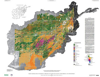
New USGS Report and Maps Highlight Afghanistan’s Mineral Potential, But Obstacles Remain
›Two maps released to the public for the first time this month illustrate the vast wealth of mineral deposits in the war-torn nation of Afghanistan. The maps, created through a joint effort from the U.S. Geological Survey and Department of Defense Task Force for Business and Stability Operations, are the first of their kind to provide large-scale coverage of a country using a technology called hyperspectral imaging, which measures the reflectance of material on the Earth’s surface simultaneously across a continuous band of wavelengths broken up into 10 to 20 nanometer intervals. More than 800 million individual pixels of data were collected during a period of 43 days in 2007 by a NASA aircraft. Each data point was then “compared to reference spectrum entries in a spectral library of minerals, vegetation, water, ice, and snow in order to characterize surface materials across the Afghan landscape.”
Two maps released to the public for the first time this month illustrate the vast wealth of mineral deposits in the war-torn nation of Afghanistan. The maps, created through a joint effort from the U.S. Geological Survey and Department of Defense Task Force for Business and Stability Operations, are the first of their kind to provide large-scale coverage of a country using a technology called hyperspectral imaging, which measures the reflectance of material on the Earth’s surface simultaneously across a continuous band of wavelengths broken up into 10 to 20 nanometer intervals. More than 800 million individual pixels of data were collected during a period of 43 days in 2007 by a NASA aircraft. Each data point was then “compared to reference spectrum entries in a spectral library of minerals, vegetation, water, ice, and snow in order to characterize surface materials across the Afghan landscape.”
Accompanying the release of the maps is a USGS study, completed in September of 2011, that largely confirms earlier reports from the DOD and USGS on the size of Afghanistan’s untapped mineral resources. The first reports received widespread media coverage last year, and updated estimates indicate that upwards of $900 billion worth of mineral reserves are present in a number of different forms including copper, iron, gold, and, most notably, more than one million metric tons of rare earth elements.
Scientists involved with the project believe that there may be even more reserves awaiting discovery. “I fully expect that our estimates are conservative,” said Robert Tucker from the USGS in an interview with Scientific American. “With more time, and with more people doing proper exploration, it could become a major, major discovery.”
Over the course of the study, scientists from the USGS and Afghan Geological Survey combined the newly-created spectral data with existing maps to identify 24 areas of interest (AOIs) that warranted hands-on investigation.
The two hyperspectral maps illustrate different parts of the electromagnetic spectrum. Shortwave infrared wavelengths reveal carbonates, phyllosilicates, and sulfates, while visible and near-infrared wavelengths show iron-bearing minerals, which yield products ranging from copper to rare earth elements and uranium. Each map classifies 31 different types of materials by color.
Although the hyperspectral maps only show mineral deposits on the surface, geologists were able to estimate what lies beneath by combining new data with samples previously taken from trenches, drill holes, or underground workings at the AOIs by Soviet and Afghan scientists. According to the USGS, “A number of the AOIs were field checked by USGS and DOD geologists between 2009 and 2011, and the previous geologic interpretations and concepts were confirmed.”
Actual Extraction: Not Easy
Afghanistan has been “scouring the globe for investors to develop its mines in an attempt to lift one of the world’s poorest nations out of misery through investment,” according to The Wall Street Journal. Contracts have already been awarded to China and India to develop copper and iron mines, respectively, and another round of bidding is currently in progress for four unexploited sites that are being closely eyed by countries such as the United States, Australia, and Turkey.
But significant hurdles remain in the quest to turn Afghanistan’s buried minerals into a steady source of income for the government and the Afghan people. Security is still a major concern and United States will pull out a vast majority of its combat troops by 2014. The government has established a Mines Protection Unit to guard sites where ground has already been broken, and plans to increase the size of the unit as necessary to provide security for all mining projects nationwide. For now the Afghan Ministry of Mines is only taking bids for projects in the more secure northern part of the country, where deposits of copper and gold are located. As the nation develops and stabilizes, massive resources of rare earth elements located in the notoriously volatile Helmand Province will open for bids.
Security isn’t the only factor affecting the country’s mining prospects. “If you want to do mineral resource development, there are two things you need to pay attention to: water and energy resources. Where is the power going to come from? You can’t develop these large mineral deposits without energy,” said director of the USGS program in Afghanistan, Jack Medlin, in an interview with EARTH magazine.
There are also the traditional pitfalls of developing extractive industries, especially in poor and conflict-prone countries, including corruption, inequity, land disputes, and environmental degradation. And the fact that Afghanistan is landlocked, making supply lines in an out of the country difficult (as the United States has discovered).
Despite the many hurdles, there is plenty of optimism for an Afghan future brightened by mineral wealth. The new data shows that previous reports of substantial resources were not far off, and the Afghan economy, which for years has relied on opium as its biggest export, could certainly use the help. “The prognosis is extremely encouraging and could play a significant role in recovery from decades of war,” USAID advisor Wayne Pennington told EARTH.
For the full resolution versions of the hyperspectral imaging maps (~90MB each) see here and here.
Keenan Dillard is a cadet at the United States Military Academy at West Point and an intern with the Woodrow Wilson Center’s Environmental Change and Security Program.
Sources: Afghan Geological Survey, Afghan Ministry of Mines, Christian Science Monitor, U.S. Department of Defense, EARTH, The New York Times, Scientific American, U.S. Geological Survey, The Wall Street Journal, World Bank.
Image Credit: USGS.
Showing posts from category Eye On.
 “The most rapid population growth in many ways [occurs in] the countries that can least afford it,” said Carl Haub in a webinar on July 19 to launch the Population Reference Bureau’s (PRB) 50th annual