-
India’s Environmental Security Challenge: Water, Coal, Natural Gas, and Climate Change Fuel Friction
›November 23, 2012 // By Michael Kugelman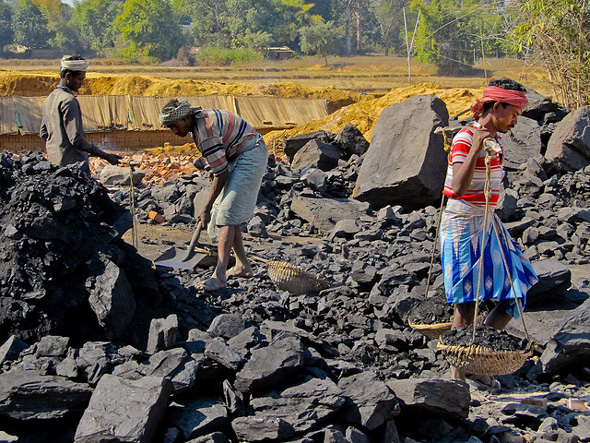
The original version of this article appeared in NATO Review.
Few regions are more environmentally insecure than South Asia.
The region faces rising sea levels and regularly experiences coastal flooding – of particular concern in a region with heavily populated and arable-land-rich coastal areas. Additionally, it is highly vulnerable to glacial melt. The Western Himalayas, which provide water supplies to much of South Asia, have experienced some of the most rapid melt in the world.
-
Connecting the Dots Between Security and Land Rights in India
›Across India, where I live and work, I can clearly see the connection between land rights and peace and security.
With respect to personal safety and security: 12 percent of all murders here are related to conflicts over land.
On a provincial level: few weeks go by without newspapers here reporting on violence between communities who are battling over land.
-
Michael D. Lemonick, Climate Central
Surprise Geoengineering Test Goes Forward Off Coast of Canada
›November 2, 2012 // By Wilson Center Staff
The original version of this article, by Michael D. Lemonick, appeared on Climate Central.
Harvard’s David Keith calls it the “goofy Goldfinger scenario” – a rogue nation, or even an individual, would conduct an unsupervised geoengineering experiment – and he confidently predicted in a story I wrote last month that it would never happen.
-
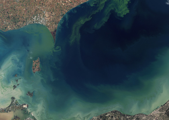
Michael Kugelman, Global Times
Repairs Could Stifle South Asia’s Water War
›October 19, 2012 // By Wilson Center StaffThe original version of this article, by Michael Kugelman, appeared on Global Times.
In recent weeks, militants in Pakistan have escalated their hostile rhetoric toward India. The subject of their ire is water. Hafiz Saeed, the head of militant Islamist group Jamaat-ud-Dawa, has warned that India plans “to make Pakistan barren” by preventing the waters of the Indus Basin from flowing downstream to Pakistan.
-
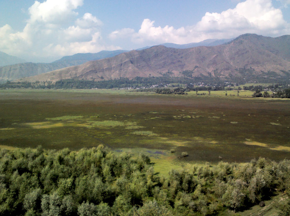
Manipadma Jena, Inter Press Service
A Lake of Hope and Conflict
›October 4, 2012 // By Wilson Center StaffThe original version of this article, by Manipadma Jena, appeared on Inter Press Service.
Parvez Ahmad Dar climbs three hours to reach the hilltop, generator-equipped tourist center in Ajaf village, 35 kilometers from Srinagar, to recharge his mobile phone.
The 46-year-old president of the Wular Valley People’s Welfare Forum is in high demand as an activist and organizer – he cannot allow the long power outages in northern India’s Kashmir Valley to cut off communication with his constituency.
-
Water and Land Conflict in Kenya in the Wake of Climate Change
›Earlier this month, there was a flurry of stories about brutal mass killings in clashes between the Pokomo and Orma communities over water and land in southeast Kenya’s Tana River County. The Kenyan media reported that about 30 people, including eight security personnel, had been killed and scores wounded, and reports on the death toll since last month are more than 100.
-
The Role of Renewable Natural Resources and Gender in Conflict
›Devesh Kapur, Kishore Gawande, and Shanker Satyanath open their Center for Global Development working paper, “Renewable Resource Shocks and Conflict in India’s Maoist Belt,” with a crucial question: “Is there a causal relationship between shocks to renewable natural resources, such as agricultural and forest lands, and the intensity of conflict?” While the connection between the environment and conflict has been the focus of much study, Kapur et al. say that previous attempts have been plagued with “failure to address reverse causality and a failure to systematically control for alternative explanations for conflict.” Their report analyzes the relationship between the availability of resources and conflict by measuring rainfall, vegetation prevalence, and deaths due to the Maoist conflict in India. They find “a strong and substantively large relationship between adverse renewable resource shocks and the intensity of conflict,” and conclude that protecting the livelihoods of residents of the Maoist belt can help reduce violence. “Giving tribals greater access to forests and a range of forest products, whose consumption is the only available option during times of distress, can provide them with a critical self-insurance mechanism.”
-
Michael Klare on the Race for What’s Left
›Around the world, as the most easily accessible natural resources are depleted, states are beginning to turn to more remote reserves to meet their needs and the shift may spark international tensions or even conflict, said Hampshire College professor Michael Klare in a recent interview with ECSP. “I worry very much about this growing global competition for the remaining resources in those parts of the world,” he said.
Showing posts from category environmental security.